next level field analysis
The AGRISTRY platform helps you to target weeds and monitor your fields all-season.
Our software uses aerial imagery and geospatial technology to automatically generate and deliver field analysis maps for precise weed detection, plant health, elevation models and more. Machinery integration allows for seamless job transfer and targeted application with your existing equipment – all managed in one platform!
Precision Agriculture made easy.
drone mapping
High Accuracy
non-Invasive
flexible
non-Invasive
flexible
field analysis
Weed Detection
Plant Health
Land Development
Plant Health
Land Development
Integration
actionable insights
diagnostic maps
Shapefiles
diagnostic maps
Shapefiles
Field Mapping for Precision Farming applications has never been so accessible.
Is this the solution to your farming needs?
Great! Sign up and get started.
Need more information?
Keep on reading or get in touch.
New Solutions
Agriculture faces many new challenges due to changes in climate, economy and regulations. We developed the AGRISTRY platform & field analysis software to help farmers overcome these challenges with new technology!
weed mapping solution
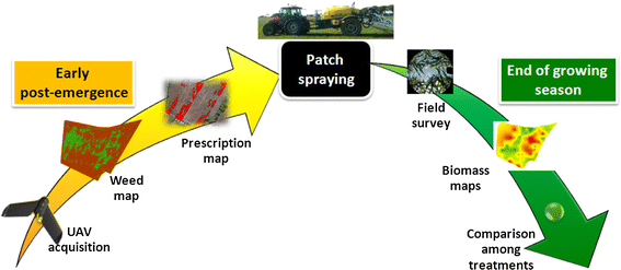
Based on aerial imagery, AGRISTRY provides actionable insights for weed control in fallow fields.
weed detection
Locate weeds in fallow fields before they become a problem.
weed management
Benefit from machinery integration to spray weeds with precision.
Weed detection and control are important, but there’s more AGRISTRY can do for you. Get the full solution!
AGRISTRY solutions
- Maps for precision field analysis & 3D land surveys
- Pre-season field mapping for weed detection & spraying
- Shapefiles for variable rate application & machinery integration
- Ongoing crop health & harvest readiness monitoring
weed mapping
Locate & treat weeds before they become a problem.
crop mapping
Monitor early crop health, stress and harvest readiness.
land mapping
Create 3D Land Models to analyse the terrain.
Using different types of field mapping can help you to take action when & where it is needed.
grow more with less
Take advantage of AGRISTRY solutions and do more with less resources, more sustainably.
Benefits
Sustainable
Improved Crop Quality
Improved Soil Longevity
Yield Increase
Increased Productivity
Increased Profit
Easy Integration
Machinery Integration
Workflow Integration
Input Reduction
Decreased Chemical Use
Time- and Cost-Saving
AGRISTRY is your way to autonomous Precision Farming. Map your fields to gain valuable insights and optimise management strategies. Achieve increased yields, reduced costs and better environmental outcomes!
Frequently asked questions
AGRISTRY is a field analysis software for farmers interested in Precision Agriculture and the possibilities of field scanning and diagnostic mapping with drones. It generates maps to support various field management tasks, from weed detection to crop health monitoring. For more information, see Product and Solutions.
Our software generates accurate field maps and provides diagnostic analysis from drone imagery that show the condition of your fields and facilitate precise crop management. The analysis uses computer vision, spatial technology and artificial intelligence as well as various parameters and plant indices. For more information, see Field Mapping.
AGRISTRY can help improve crop health and increase yield while saving time and money. Farmers receive locally precise field data that facilitates the design of efficient treatment strategies and prescription application. AGRISTRY is your way to easy crop monitoring and precision farming.
Our prices vary depending on the type of field mapping solution. They are calculated per hectare. For more information, contact us.
Generally yes. However, AGRISTRY field mapping and analysis is based on drone imagery and aimed at precision application via machinery integration. To use its full potential, farmers need drone scans of their fields and machinery capable of variable rate spraying and section control.
To register or log in, click here, use any “Sign Up” button or the “My AGRISTRY” button in the top right corner. Once you created an account, simply upload drone imagery to start the field mapping and analysis.
AGRISTRY is a field mapping software for precision farming. For more information, see FAQ.
Our Journey
AGRISTRY is an Agricultural Technology Startup Company.
We offer a new Software as a Service (SaaS) solution for Precision Farming which is currently being tested in case studies with a select group of Australian farmers. The AGRISTRY platform and our weed mapping solution are continually optimised and will be fully available soon.
We created this platform because we are dedicated to help farmers enter a new era of agriculture. With technologies advancing and becoming more essential for sustainable growth in a changing world, farming needs to adapt. Our goal is to support farmers in increasing productivity & yield by developing new agricultural technology solutions.
AGRISTRY is working closely with farmers, collaborating with industry-leading identities, and is a proud member of The Agricultural Industry Electronics Foundation (AEF). We know that farming is of vital importance and believe that we can achieve great things together!
Get in touch to become a part of progress, we look forward to working with you!