Solutions
precision agriculture made easy
Our Solutions
We are committed to providing innovative solutions that help farmers optimize their operations and design effective field management strategies. Identify and target particular zones in your fields with our AGRISTRY mapping solutions for weed detection, crop health monitoring and land surveying. Take full advantage of the benefits of Precision Agriculture!
what we offer
Our solutions provide farmers with insightful map-based information for various field management and monitoring purposes.
AGRISTRY solutions
- Maps for precision field analysis & 3D land surveys
- Pre-season field mapping for weed detection & spraying
- Shapefiles for variable rate application & machinery integration
- Ongoing crop health & harvest readiness monitoring

Help your crops grow with drone based field analysis.
Is this the solution to your farming needs?
Great! Sign up and get started.
Need more information?
Keep on reading or get in touch.
How it works
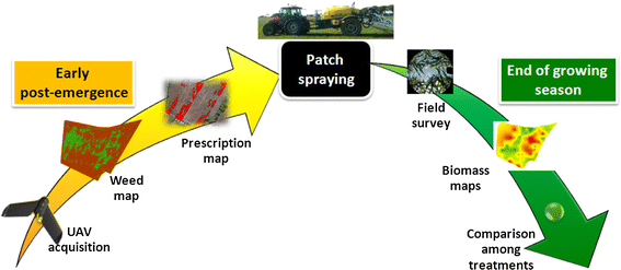
With our platform, you can create field maps from aerial image data for precision applications. Use Weed Mapping as example:
Three-Step Process
- Capture aerial imagery
- Create weed map and shapefile
- Targeted herbicide application
Result: Improved field conditions for crop production!

To benefit from AGRISTRY, all you need to do is sign up to the platform and upload your drone imagery. Our software identifies patterns within the image data to deliver insightful field analysis using computer vision, artificial intelligence and geospatial technology. Download the generated diagnostic maps and the application files to implement the solutions using your existing machinery.
precision agriculture made easy.
Be part of Progress
Benefit from precision farming and protect the environment with drone field monitoring!
Benefits
Sustainable
Improved Crop Quality
Improved Soil Longevity
Yield Increase
Increased Productivity
Increased Profit
Easy Integration
Machinery Integration
Workflow Integration
Input Reduction
Decreased Chemical Use
Time- and Cost-Saving
AGRISTRY is your way to autonomous Precision Farming. Map your fields to gain valuable insights and optimise management strategies. Achieve increased yields, reduced costs and better environmental outcomes!
